We’d always planned to do some hiking while we were up here in the Upper Peninsula, and we chose the Chapel-Mosquito Trail.
Getting there was an ordeal: first, a drive of about 30 miles, then 5 miles down a dirt-track road which really requires an off-road vehicle (not our Nissan Versa, taxed to its extreme by the potholes and stones as everyone else’s 4x4s whizzed on by). Finally, we reached our starting point. But was it worth while? You be the judge…
It took us five hours in all to cover about 10 miles of the trail. Of course, we had to stop for some photo-opportunities, and occasionally to pick our jaws up off the floor. The dunnies are made for outdoorsy types. Like flies and sloths. But that aside, it’s a walk in the park. Hiawatha National Park, to be precise.
First, there’s a pleasant stroll through densely wooded forest, skirting the Chapel Lake and ending at the Chapel Falls viewpoints. This is relatively easy-going, and for anyone pressed for time, about a 3m round trip, rewarded with these views:
But we ploughed on as the terrain got more rugged, weaving up and down with many tree roots and fallen trunks crossing the path. Nothing treacherous or arduous, but a good workout, making us feel that we’d earned our lunch when we stopped at Chapel Beach.
What can we say? Look at the turquoise water. No crowds, not an ice-cream vendor in sight. And at one corner of the cove, the extraordinary Chapel Rock – given its name in 1840 by the earliest Westerners to survey the southern landscape of Lake Superior.
From here, the hike hugs the coastline, giving ample views of what are known as the Pictured Rocks, sheer sandstone formations that have been layered with different colours as the height of water has changed over time. It reminded us of some of the rock formations in Death Valley, particularly the Artists Palette.
After about four miles, the hike crosses over the Mosquito River and heads inland once again, this time to the Mosquito Falls, by now around 9 miles into our trek, and – we were relieved to know – only another mile or so back to the parking lot.
Wowzers! This was the best day. Loved it – and when the blisters have gone down, we’ll definitely be back for more.
One of the things that has struck us in our journeying through America is how many dangers lurk around corners. We had already been warned about the Mountain Lions and Rattlers; but Yosemite is a whole nuther ball game. Here there are also several breeds of branded Yosemite mosquito, extensive evidence of forest fires that have been raging throughout California, and rock falls or precipitous drops on each side of the road. Then there’s the plague, carried in these parts by your friendly neighbourhood chipmunk (and caught by at least two humans this summer). And finally, the bears. We had to remove absolutely everything from the car in case it was raided and torn apart by hungry animals looking for a Hershey Bar.
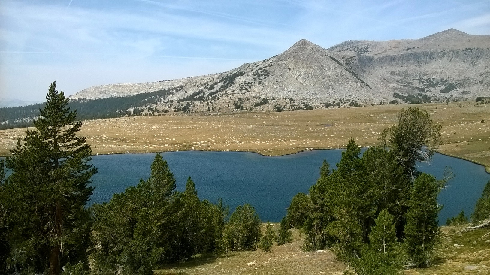
Armed and ready, though, we decided to trek out into the Yosemite wilderness. We chose to do the Gaylor Lakes Trail, which was fairly short, but which took us up a steep, forested embankment to about 10,500 feet, before opening out into a flat grassland with several beautiful mountain lakes.
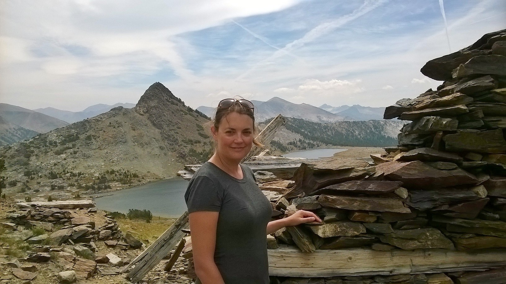
Dominic said Karen could star in this pic…
The views from the top of the trail were absolutely stunning, particularly those looking back on Yosemite behind us. Beyond the far end of the second lake was a narrow path leading up to the Great Sierra Mine, a remote silver mine dating back to about 1880.
Now, with silver selling for about $14 an ounce (compared to gold’s $1133 per ounce), you can see why it has gone into something of a decline; and the two hour hike to the top of the mine shaft doesn’t exactly make the Great Sierra seam cost-effective any more. Nevertheless, it was this sort of a seam that William Randolph Hearst’s father mined in the 1840s, lugging 38 tons of the stuff back over the mountains to San Francisco. Well, we saw what came of that – it was obviously worth a pretty penny back in the day.
Our hike was truly exhilarating and we had a real sense of satisfaction in reaching the silver mine. And, although you do need to take the wilderness seriously and heed the warnings, the benefits of this wonderful place far exceed the potential hazards (we were quite disappointed not to see any bears – although probably for the best).
But today’s adventures were really only beginning.
We’d come to this side of the park for a very particular reason – to see the extraordinary tufa sculptures of Mono Lake. After a spot of lunch we drove into the lakeside town of Lee Vining, and were at first a bit disheartened because smoke from the Sequoia Park forest fire had completely overcast the sky, making our chance of seeing these sculptures more or less impossible. However, we stopped in at the visitors centre, run by Mono Lake Committee, and watched their promotional film about the lake and their efforts to save it. This really altered our perspective on the lake, and following the advice of a really helpful volunteer from the committee, we opted to go on the guided tour later that evening, by which time, we hoped, the smoke would have cleared.
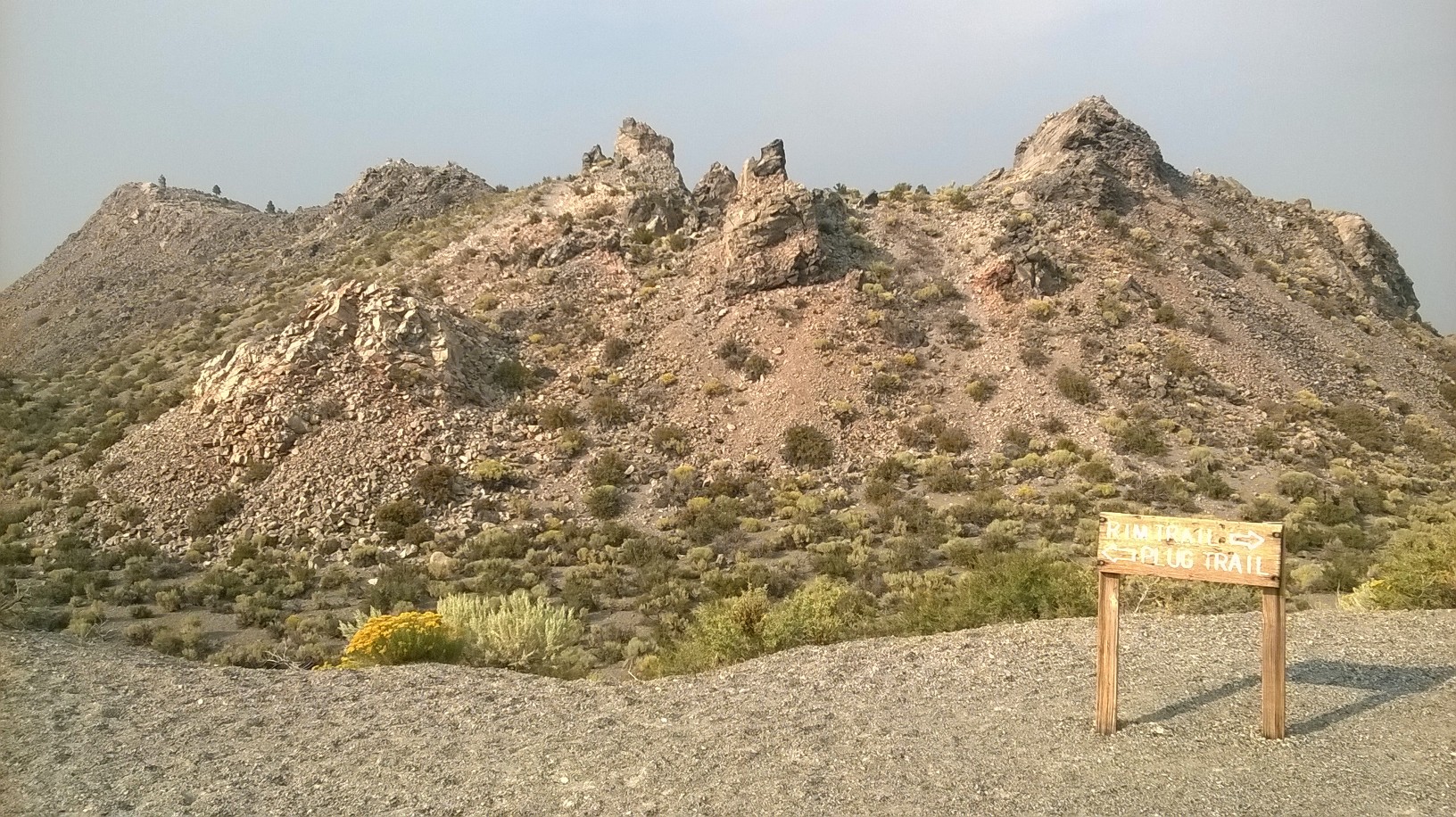
So with a bit of time to kill we climbed a volcano.
This was the Panum Crater, a plug volcano that was formed only about 650 years ago. It’s just a short off-road drive from the highway, and easy to hike up through the pumice field to take a look at the plug itself.
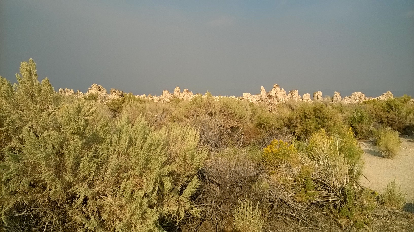
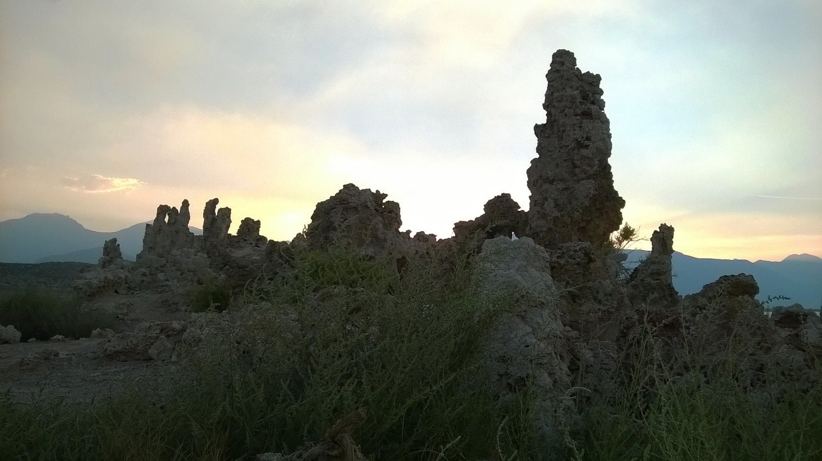
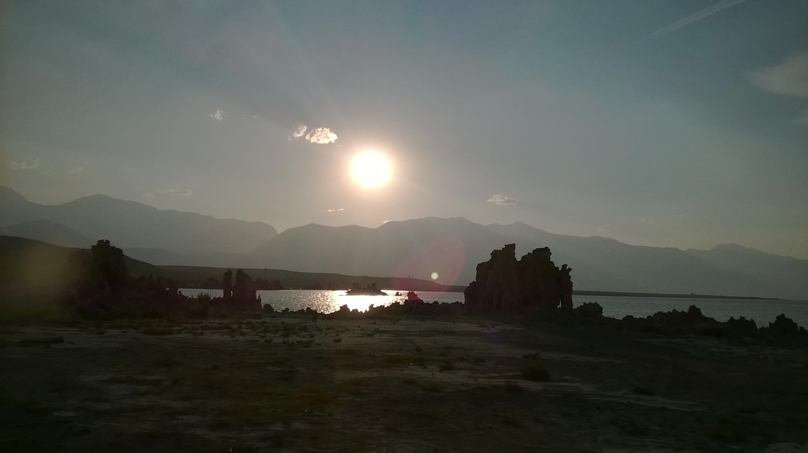
By the time we came down, the sky was beginning to clear a bit, so we ventured further on to the South Tufa beach area, where we met up with our wonderful and very knowledgeable guide Andrew.
Mono Lake is extraordinary, as you can see from these pictures. And the tufa, which are limestone sculptures formed when fresh water streams bubble into the alkali waters of the lake, are ghostly, ethereal and other-wordly. They give the place the look of a lunar landscape, or a prehistoric terrain. Strangely, though, we were told they are probably only about 200 years old.
However, although most visitors come to see the lake in order to gaze at these extraordinary tufas, the story of the lake itself is even more extraordinary, and it was this that really turned our interest in Mono Lake on its head. It transpires that these tufas were all formed underwater, and that until 1941, the Lake would have been several vertical feet higher, and covering significantly more land. But in 1941, the city of Los Angeles (over 300 miles away) decided to pipe water from the surrounding streams by aqueduct to supply the growing city, and as a result the lake shrank in size, devastating its natural ecology and threatening its habitat. It was only thanks to the decades-long battle of the Mono Lake Committee that a landmark victory was achieved against the big boys in LA. In 1994, a high court ruled that the diverted watercourses should be rerouted to feed the lake again until it had reached a compromise level. The good news is that the ecosystem of the lake has been saved, and it has now risen several vertical feet; the bad news is that current drought conditions have presented a natural threat to the ongoing security of the lake. It looks like it will be several years before the lake reaches the height that was agreed by that landmark ruling. But we have been really inspired by the work of the committee in rescuing this extraordinary place and in saving the lake for the birds and marine life that inhabit it.
This whole area, if you are travelling in California, is an absolute MUST-SEE. The marketing material states that Yosemite is the ‘best place on earth’…they could be right!